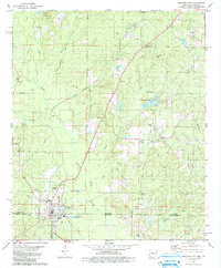
1981 Map of Junction City
USGS Topo · Published 1981About this map
Junction City straddles the state line in this early 1980s look at the borderlands between Arkansas and Louisiana. The landscape is defined by the winding course of Little Cornie Bayou and its numerous tributaries, including Beech Creek and Turkey Creek. The map documents a rural community connected by small settlements like Caledonia and Upland, with evidence of the regional energy economy found in the South El Dorado Oil Field and scattered Oil Well and Drill Hole markings.
Find a feature on this map
44 named features on this map. Tap any name to fly to it.
Don’t see what you’re looking for? This feature index may not catch every label — zoom into the map to look around manually.
Map Details
Editions of this 1981 Junction City Map
This is the sole edition of this map. No revisions or reprints were ever made.
Other maps of this area

1927 · El Dorado
USGS Topo · 1:62,500

1930 · El Dorado
USGS Topo · 1:62,500

1951 · Summerfield
USGS Topo · 1:62,500

1951 · Bernice
USGS Topo · 1:62,500

1951 · El Dorado
USGS Topo · 1:62,500

1953 · El Dorado
USGS Topo · 1:250,000

1955 · Shreveport
USGS Topo · 1:250,000

1956 · Shreveport
USGS Topo · 1:250,000

1957 · El Dorado
USGS Topo · 1:250,000

1958 · El Dorado
USGS Topo · 1:250,000