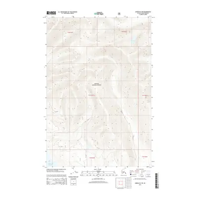
2015 Map of Juneau B-4 SW
USGS Topo · Published 2015About this map
Tongass National Forest dominates this coastal landscape, where the high ridges of the Alaska panhandle descend toward the Pacific. The southern edge of the sheet meets the maritime environment of the Gulf of Alaska and the Icy Strait, where the shoreline is defined by the Icy Flats. Moving inland, the topography is marked by steep elevations and glacial valleys like Bear Valley, punctuated by isolated alpine water bodies such as Teardrop Lake. The land is largely uninhabited, characterized by the rugged wilderness of the Kushtakaa terrain. This 2015 edition provides a detailed look at the hydrology and contour of the region, including the seasonal water levels at Lake View and the complex drainage patterns feeding into the straits.
Find a feature on this map
14 named features on this map. Tap any name to fly to it.
Don’t see what you’re looking for? This feature index may not catch every label — zoom into the map to look around manually.
Map Details
Editions of this 2015 Juneau B-4 SW Map
This is the sole edition of this map. No revisions or reprints were ever made.
Other maps of this area

1948 · Juneau B-4
USGS Topo · 1:63,360

1948 · Juneau A-4
USGS Topo · 1:63,360

1948 · Juneau B-5
USGS Topo · 1:63,360

1949 · Juneau B-4
USGS Topo · 1:63,360

1950 · Juneau B-5
USGS Topo · 1:63,360

1951 · Juneau
USGS Topo · 1:250,000

1951 · Juneau A-5
USGS Topo · 1:63,360

1962 · Juneau
USGS Topo · 1:250,000
1994 · Juneau A-5
USGS Topo · 1:63,360
1995 · Juneau A-4
USGS Topo · 1:63,360