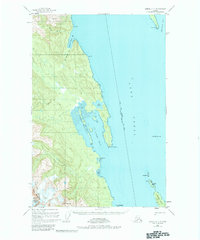
1949 Map of Juneau C-4
USGS Topo · Published 1984About this map
The Chilkat Range rises sharply above the waters of the Lynn Canal in this mid-century survey of the Alaskan coast. This area represents a significant administrative boundary where the City and Borough of Juneau Haines Borough line crosses the channel. Much of the western terrain is protected under the Glacier Bay National Monument, while the eastern forest lands fall within the Tongass National Forest.
Find a feature on this map
24 named features on this map. Tap any name to fly to it.
Don’t see what you’re looking for? This feature index may not catch every label — zoom into the map to look around manually.
Map Details
Editions of this 1949 Juneau C-4 Map
2 editions found
Other maps of this area

1947 · Juneau B-3
USGS Topo · 1:63,360

1948 · Juneau C-5
USGS Topo · 1:63,360

1948 · Juneau B-4
USGS Topo · 1:63,360

1948 · Juneau C-4
USGS Topo · 1:63,360

1948 · Juneau B-5
USGS Topo · 1:63,360

1948 · Juneau D-3
USGS Topo · 1:63,360

1949 · Juneau B-3
USGS Topo · 1:62,500

1949 · Juneau D-5
USGS Topo · 1:63,360

1949 · Juneau D-4
USGS Topo · 1:63,360

1949 · Juneau C-4
USGS Topo · 1:63,360