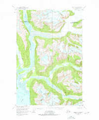
1948 Map of Juneau D-3
USGS Topo · Published 1976About this map
Tongass National Forest dominates this topographic landscape, documenting the glacial river systems and coastal inlets north of Juneau as they were recorded in the late 1940s. The convergence of the Lace River, Berners River, and Antler River into Berners Bay highlights a complex network of glacial silt and braided channels, notably the extensive mud flats at the river mouths. High-altitude ice fields and features like Antler Glacier feed the local hydrology, while Antler Lake sits nestled between the steep drainage of the Gilkey River and the coast. Human presence is sparse in this period, indicated only by a solitary Cabin near the bay, positioned along the jurisdictional boundary between the Haines Borough and the City and Borough of Juneau.
Find a feature on this map
11 named features on this map. Tap any name to fly to it.
Don’t see what you’re looking for? This feature index may not catch every label — zoom into the map to look around manually.
Map Details
Editions of this 1948 Juneau D-3 Map
3 editions found
Other maps of this area

1948 · Juneau C-4
USGS Topo · 1:63,360

1948 · Juneau D-3
USGS Topo · 1:63,360

1948 · Skagway A-1
USGS Topo · 1:63,360

1949 · Atlin
USGS Topo · 1:250,000

1949 · Juneau D-4
USGS Topo · 1:63,360

1949 · Juneau C-4
USGS Topo · 1:63,360

1949 · Juneau D-3
USGS Topo · 1:63,360

1951 · Juneau
USGS Topo · 1:250,000

1951 · Skagway A-1
USGS Topo · 1:63,360

1951 · Atlin
USGS Topo · 1:250,000