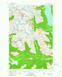
1949 Map of Juneau D-5
USGS Topo · Published 1963About this map
The Chilkat Range dominates this mid-century topographic survey, marking the dramatic boundary between two of Alaska's most significant protected landscapes. To the west, the Glacier Bay National Monument encompasses ice-carved peaks and extensive crevasses, while to the east, the Tongass National Forest stretches toward the deep waters of Lynn Canal. The topographical detail focuses on the sharp elevation changes around Mt Young, illustrating the glaciated terrain that defines the region's wilderness character.
Find a feature on this map
11 named features on this map. Tap any name to fly to it.
Don’t see what you’re looking for? This feature index may not catch every label — zoom into the map to look around manually.
Map Details
Editions of this 1949 Juneau D-5 Map
3 editions found
Other maps of this area

1948 · Juneau C-5
USGS Topo · 1:63,360

1948 · Juneau C-4
USGS Topo · 1:63,360

1948 · Juneau C-6
USGS Topo · 1:63,360

1948 · Skagway A-1
USGS Topo · 1:63,360

1949 · Juneau D-6
USGS Topo · 1:63,360

1949 · Juneau D-5
USGS Topo · 1:63,360

1949 · Juneau D-4
USGS Topo · 1:63,360

1949 · Juneau C-4
USGS Topo · 1:63,360

1950 · Juneau C-6
USGS Topo · 1:63,360

1951 · Juneau
USGS Topo · 1:250,000