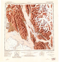
1951 Map of Juneau
USGS Topo · Published 1954About this map
Juneau and its surrounding waterway networks are documented here in the early 1950s, showing the capital city alongside its industrial and maritime neighbors. The map illustrates the concentration of settlements along the Gastineau Channel, including Douglas, Treadwell, and Thane, which was the primary corridor for regional commerce and mining activity during this era. Further west, the map details the expansive boundaries of Glacier Bay National Monument and the early layout of Gustavus near Icy Passage. This reconnaissance survey provides a comprehensive view of the transition from industrial mining towns to the established coastal communities of Southeast Alaska, capturing the landscape before the significant 20th-century expansions of the Juneau Airport and regional transportation infrastructure. The proximity of the United States Canada border to the east, marked by the Coast Mountains, highlights the geographic isolation and reliance on water routes like Lynn Canal for connectivity.
Find a feature on this map
64 named features on this map. Tap any name to fly to it.
Don’t see what you’re looking for? This feature index may not catch every label — zoom into the map to look around manually.
Map Details
Editions of this 1951 Juneau Map
4 editions found

Other maps of this area

1947 · Juneau B-3
USGS Topo · 1:63,360

1947 · Juneau B-2
USGS Topo · 1:63,360

1948 · Juneau C-5
USGS Topo · 1:63,360

1948 · Juneau B-4
USGS Topo · 1:63,360

1948 · Juneau A-3
USGS Topo · 1:63,360

1948 · Juneau B-6
USGS Topo · 1:63,360

1948 · Juneau C-4
USGS Topo · 1:63,360

1948 · Juneau A-4
USGS Topo · 1:63,360

1948 · Sitka D-1
USGS Topo · 1:63,360

1948 · Juneau C-6
USGS Topo · 1:63,360