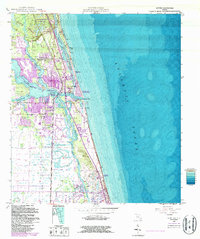
1948 Map of Jupiter
USGS Topo · Published 1986About this map
The confluence of the Loxahatchee River and the Atlantic Ocean defines this coastal landscape, where the Jupiter Inlet Light has long guided mariners through the dangerous waters of Jupiter Inlet. This survey, based on 1940s field work with 1980s updates, captures the mid-century expansion of Jupiter and Tequesta along the banks of the North Fork and Southwest Fork. The transportation corridor is anchored by the Florida East Coast Railway and the winding Intracoastal Waterway, which snakes behind Jupiter Island.
Find a feature on this map
30 named features on this map. Tap any name to fly to it.
Don’t see what you’re looking for? This feature index may not catch every label — zoom into the map to look around manually.
Map Details
Editions of this 1948 Jupiter Map
5 editions found
Other maps of this area

1945 · Delta
USGS Topo · 1:24,000

1946 · Riviera Beach
USGS Topo · 1:24,000

1948 · Rood
USGS Topo · 1:24,000

1948 · Gomez
USGS Topo · 1:24,000

1948 · Hobe Sound
USGS Topo · 1:24,000

1948 · Jupiter
USGS Topo · 1:24,000

1949 · Rood
USGS Topo · 1:24,000

1949 · Gomez
USGS Topo · 1:24,000

1949 · Riviera Beach
USGS Topo · 1:24,000

1949 · Hobe Sound
USGS Topo · 1:24,000