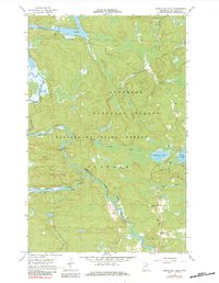
1967 Map of Kabustasa Lake
USGS Topo · Published 1984About this map
The Vermilion River and Pelican River dictate the movement and layout of this wilderness landscape, where water routes have long served as primary corridors. In the southern portion of the sheet, the small settlement of Buyck serves as a lone hub of activity, accompanied by the Forest Home Cem and a local Radio Tower. The geography is defined by the intersection of the Superior National Forest and Kabetogama State Forest, showing a transition from water-based travel to early infrastructure.
Find a feature on this map
19 named features on this map. Tap any name to fly to it.
Don’t see what you’re looking for? This feature index may not catch every label — zoom into the map to look around manually.
Map Details
Editions of this 1967 Kabustasa Lake Map
3 editions found
Other maps of this area

1954 · International Falls
USGS Topo · 1:250,000

1957 · International Falls
USGS Topo · 1:250,000

1958 · International Falls
USGS Topo · 1:250,000

1963 · Echo Lake
USGS Topo · 1:24,000

1963 · Picket Lake
USGS Topo · 1:24,000

1963 · Crane Lake
USGS Topo · 1:24,000

1967 · Kabustasa Lake
USGS Topo · 1:24,000

1967 · Marion Lake
USGS Topo · 1:24,000

1967 · Elephant Lake
USGS Topo · 1:24,000
1967 · Buyck
USGS Topo · 1:24,000