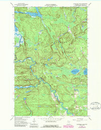
1967 Map of Kabustasa Lake
USGS Topo · Published 1987About this map
The Vermilion River and Pelican River wind through this heavily forested northern landscape, where the Kabetogama State Forest meets the Superior National Forest. This terrain is defined by its water and timber history, centered on the small settlement of Buyck, which serves as a remote hub for the surrounding wilderness. Cultural landmarks like the Forest Home Cem and the Vermilion Lake Indian Res mark the long-standing human presence in the area, while the Crane Lake Lookout Tower and a Radio Tower emphasize the region's management and communication needs.
Find a feature on this map
19 named features on this map. Tap any name to fly to it.
Don’t see what you’re looking for? This feature index may not catch every label — zoom into the map to look around manually.
Map Details
Editions of this 1967 Kabustasa Lake Map
3 editions found
Other maps of this area

1954 · International Falls
USGS Topo · 1:250,000

1957 · International Falls
USGS Topo · 1:250,000

1958 · International Falls
USGS Topo · 1:250,000

1963 · Echo Lake
USGS Topo · 1:24,000

1963 · Picket Lake
USGS Topo · 1:24,000

1963 · Crane Lake
USGS Topo · 1:24,000

1967 · Kabustasa Lake
USGS Topo · 1:24,000

1967 · Marion Lake
USGS Topo · 1:24,000

1967 · Elephant Lake
USGS Topo · 1:24,000
1967 · Buyck
USGS Topo · 1:24,000