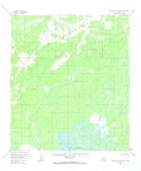
1953 Map of Kantishna River A-4
USGS Topo · Published 1973About this map
Kuskokwim Mountains dominate this interior landscape, where the peaks of the northern range meet a complex system of muskeg and glacial drainages. This mid-century survey, based on 1952 aerial photography, documents a wilderness devoid of roads or permanent settlements at the time of the study. The southern portion of the sheet is defined by the wandering course of the Muddy River, which feeds into a dense network of unnamed ponds and smaller tributaries. The contour lines, set at 100-foot intervals, reveal a terrain of high ridges and deep valleys that characterize this remote portion of the Alaskan interior before modern infrastructure reached the area.
Find a feature on this map
2 named features on this map. Tap any name to fly to it.
Don’t see what you’re looking for? This feature index may not catch every label — zoom into the map to look around manually.
Map Details
Editions of this 1953 Kantishna River A-4 Map
3 editions found
Other maps of this area

1948 · Kantishna River
USGS Topo · 1:250,000

1951 · Kantishna River
USGS Topo · 1:250,000

1952 · Mount McKinley
USGS Topo · 1:250,000

1952 · Kantishna River A-3
USGS Topo · 1:63,360

1952 · Kantishna River
USGS Topo · 1:250,000

1952 · Kantishna River A-5
USGS Topo · 1:63,360

1952 · Kantishna River B-5
USGS Topo · 1:63,360

1952 · Mount McKinley D-3
USGS Topo · 1:63,360

1953 · Kantishna River B-4
USGS Topo · 1:63,360

1953 · Kantishna River A-4
USGS Topo · 1:63,360