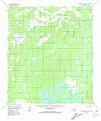
1953 Map of Kantishna River A-4
USGS Topo · Published 1981About this map
The Kuskokwim Mountains dominate this 1950s interior Alaskan landscape, providing a topographical study of the region before significant modern development. The northern section of the map reveals the high elevations of the range, including the peak at Vabm 2545 Dean. To the south, the terrain transitions into a complex network of wetlands and meandering waterways centered on the Muddy River. This contrast between the elevated mountain ridges and the saturated lowland basins illustrates the typical drainage patterns of the Yukon-Koyukuk region. With no roads or trails indicated on the sheet, the map documents a wilderness primarily defined by its natural topography and seasonal water levels.
Find a feature on this map
3 named features on this map. Tap any name to fly to it.
Don’t see what you’re looking for? This feature index may not catch every label — zoom into the map to look around manually.
Map Details
Editions of this 1953 Kantishna River A-4 Map
3 editions found
Other maps of this area

1948 · Kantishna River
USGS Topo · 1:250,000

1951 · Kantishna River
USGS Topo · 1:250,000

1952 · Mount McKinley
USGS Topo · 1:250,000

1952 · Kantishna River A-3
USGS Topo · 1:63,360

1952 · Kantishna River
USGS Topo · 1:250,000

1952 · Kantishna River A-5
USGS Topo · 1:63,360

1952 · Kantishna River B-5
USGS Topo · 1:63,360

1952 · Mount McKinley D-3
USGS Topo · 1:63,360

1953 · Kantishna River B-4
USGS Topo · 1:63,360

1953 · Kantishna River A-4
USGS Topo · 1:63,360