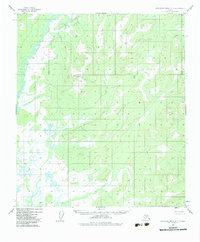
1952 Map of Kantishna River A-5
USGS Topo · Published 1983About this map
North Fork Kuskokwim River defines the western reaches of this interior Alaskan landscape, meandering through a complex network of wetlands and small ponds. The terrain is characterized by low-lying drainages that contrast sharply with the prominent elevation of Haystack Mountain in the central portion of the quadrangle. These topographic data were captured via photogrammetric methods from aerial photography taken in 1952, revealing an area devoid of established roads or trails during the mid-twentieth century. The land lines depicted on the sheet represent unsurveyed locations predetermined by the Bureau of Land Management, reflecting the remote nature of the territory north of the Alaska Range. Researchers and geographers can trace the intricate hydrology of the Kuskokwim watershed and the specific elevation points that stand as solitary landmarks in this unpopulated wilderness.
Find a feature on this map
2 named features on this map. Tap any name to fly to it.
Don’t see what you’re looking for? This feature index may not catch every label — zoom into the map to look around manually.
Map Details
Editions of this 1952 Kantishna River A-5 Map
3 editions found
Other maps of this area

1948 · Kantishna River
USGS Topo · 1:250,000

1951 · Kantishna River
USGS Topo · 1:250,000

1952 · Mount McKinley
USGS Topo · 1:250,000

1952 · Kantishna River
USGS Topo · 1:250,000

1952 · Kantishna River B-6
USGS Topo · 1:63,360

1952 · Kantishna River A-5
USGS Topo · 1:63,360

1952 · Kantishna River A-6
USGS Topo · 1:63,360

1952 · Kantishna River B-5
USGS Topo · 1:63,360

1953 · Kantishna River B-4
USGS Topo · 1:63,360

1953 · Kantishna River A-4
USGS Topo · 1:63,360