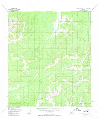
1953 Map of Kantishna River B-4
USGS Topo · Published 1974About this map
The Bitzhtini Mountains and Kuskokwim Mountains dominate this 1950s interior Alaska landscape, reflecting a time when this region remained largely unsurveyed on the ground. This map, based on 1952 aerial photography, documents the headwaters and drainages that defined travel and subsistence before modern infrastructure. The North Fork Kuskokwim River winds across the southern reaches, while the Cosna River and Zitziana River cut through the northern and eastern sections. High-elevation survey markers like VABM 3196 Extra and VABM 2653 Kus provided the necessary technical anchors for mapping this remote wilderness. The lack of named settlements or roads highlights the isolation of this terrain, where the natural water systems and mountain ranges were the primary landmarks for navigators and hunters.
Find a feature on this map
9 named features on this map. Tap any name to fly to it.
Don’t see what you’re looking for? This feature index may not catch every label — zoom into the map to look around manually.
Map Details
Editions of this 1953 Kantishna River B-4 Map
2 editions found
Other maps of this area

1948 · Kantishna River
USGS Topo · 1:250,000

1951 · Kantishna River
USGS Topo · 1:250,000

1952 · Kantishna River A-3
USGS Topo · 1:63,360

1952 · Kantishna River C-5
USGS Topo · 1:63,360

1952 · Kantishna River
USGS Topo · 1:250,000

1952 · Kantishna River A-5
USGS Topo · 1:63,360

1952 · Kantishna River B-5
USGS Topo · 1:63,360

1952 · Kantishna River C-3
USGS Topo · 1:63,360

1952 · Kantishna River C-4
USGS Topo · 1:63,360

1953 · Kantishna River B-4
USGS Topo · 1:63,360