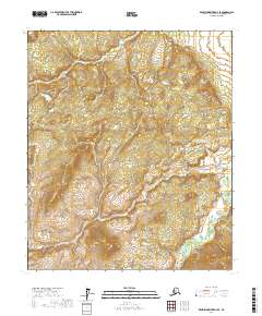
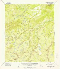
2017 Map of Kantishna River D-4 SE
USGS Topo · Published 2017About this map
Chitanatala Mountains define the southern landscape of this remote Yukon-Koyukuk interior, providing a dramatic vertical contrast to the winding path of the Cosna River. The river traverses the eastern sections of the quadrangle, carving a serpentine route through the lowlands as it flows northward. This 2017 edition illustrates the complex hydrography of the Alaskan interior, showing how the drainage patterns are strictly governed by the proximity of the mountains. Beyond the primary waterway, the terrain is marked by a network of smaller drainages and shifting elevations across the township and range boundaries of t1n r20w, t1s r21w, and t2s r20w. This specific survey offers a detailed view of an area shaped by glacial and fluvial processes, where the presence of the Cosna River indicates a dynamic landscape of seasonally changing water levels and wilderness navigation.
Find a feature on this map
9 named features on this map. Tap any name to fly to it.
Don’t see what you’re looking for? This feature index may not catch every label — zoom into the map to look around manually.
Map Details
Editions of this 2017 Kantishna River D-4 SE Map
This is the sole edition of this map. No revisions or reprints were ever made.
Other maps of this area

1948 · Kantishna River
USGS Topo · 1:250,000

1951 · Kantishna River
USGS Topo · 1:250,000

1952 · Kantishna River
USGS Topo · 1:250,000

1952 · Kantishna River D-3
USGS Topo · 1:63,360

1952 · Kantishna River C-3
USGS Topo · 1:63,360

1952 · Kantishna River C-4
USGS Topo · 1:63,360
1953 · Kantishna River D-4
USGS Topo · 1:63,360
1954 · Kantishna River D-3
USGS Topo · 1:63,360
1954 · Kantishna River D-4
USGS Topo · 1:63,360
1954 · Kantishna River C-3
USGS Topo · 1:63,360