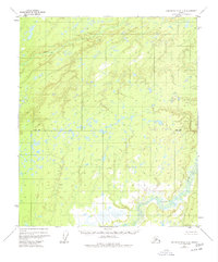
1952 Map of Kantishna River D-5
USGS Topo · Published 1977About this map
Chitanana River defines the southeastern corner of this landscape, winding through a vast system of wetlands and small interior lakes. The terrain is characterized by intricate drainage patterns and thousands of small water bodies, largely interpreted from 1952 aerial photography. These wetlands, surveyed in cooperation with the Bureau of Land Management, represent an unsurveyed wilderness where the Base Line serves as one of the few formal geographic markers. In the northern reaches, Boney Creek meanders through the lowlands, illustrating the complex hydrological network of the Yukon-Koyukuk region before significant modern alteration. The map reveals the raw, unsettled state of the Alaskan interior during the mid-twentieth century, dominated by marshland and unnamed tributaries.
Find a feature on this map
3 named features on this map. Tap any name to fly to it.
Don’t see what you’re looking for? This feature index may not catch every label — zoom into the map to look around manually.
Map Details
Editions of this 1952 Kantishna River D-5 Map
3 editions found
Other maps of this area

1948 · Kantishna River
USGS Topo · 1:250,000

1951 · Kantishna River
USGS Topo · 1:250,000

1951 · Tanana
USGS Topo · 1:250,000

1952 · Tanana A-4
USGS Topo · 1:63,360

1952 · Kantishna River C-5
USGS Topo · 1:63,360

1952 · Kantishna River C-6
USGS Topo · 1:63,360

1952 · Kantishna River D-5
USGS Topo · 1:63,360

1952 · Kantishna River
USGS Topo · 1:250,000

1952 · Tanana A-6
USGS Topo · 1:63,360

1952 · Kantishna River D-6
USGS Topo · 1:63,360