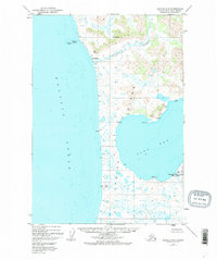
1952 Map of Karluk A-2
USGS Topo · Published 1975About this map
The Ayakulik River flows across this coastal expanse of Kodiak Island, meeting the Pacific Ocean near the small settlement of Ayakulik. This 1952 topographic study, which falls within the Kodiak National Wildlife Refuge, reveals a landscape defined by isolated cabins and small outposts rather than established towns. Along the eastern edge, the Fish and Wildlife Service Upper Station sits near the head of Olga Bay, marking a point of administrative and scientific activity in an otherwise remote region. The map highlights the sparse human footprint of the era, with labels like Tundra, Mud, and Sandy identifying specific coastal locations. Prominent peaks such as Mt Myrtle and Oval Mtn provide terrestrial navigation points above the winding river valley, while maritime features like Stormy Pt and Ayakulik Island define the complex shoreline of southwest Kodiak.
Find a feature on this map
29 named features on this map. Tap any name to fly to it.
Don’t see what you’re looking for? This feature index may not catch every label — zoom into the map to look around manually.
Map Details
Editions of this 1952 Karluk A-2 Map
3 editions found
Other maps of this area

1951 · Trinity Islands
USGS Topo · 1:250,000

1951 · Karluk
USGS Topo · 1:250,000

1952 · Karluk
USGS Topo · 1:250,000

1952 · Trinity Islands D-2
USGS Topo · 1:63,360

1952 · Karluk B-2
USGS Topo · 1:63,360

1952 · Karluk B-1
USGS Topo · 1:63,360

1952 · Trinity Islands D-1
USGS Topo · 1:63,360

1952 · Karluk A-1
USGS Topo · 1:63,360
1952 · Karluk B-3
USGS Topo · 1:63,360

1952 · Karluk A-2
USGS Topo · 1:63,360