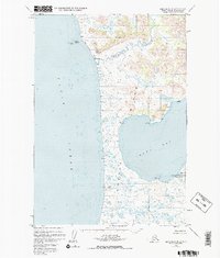
1952 Map of Karluk A-2
USGS Topo · Published 1975About this map
Kodiak Island is defined here by the confluence of the Ayakulik River and the sweeping reach of Olga Bay. This 1952 topographic study, revised in the early 1970s, documents a landscape managed primarily within the Kodiak National Wildlife Refuge. While the interior is dominated by peaks like Mt Myrtle and Oval Mtn, the coastline is marked by small settlements and resource outposts.
Find a feature on this map
23 named features on this map. Tap any name to fly to it.
Don’t see what you’re looking for? This feature index may not catch every label — zoom into the map to look around manually.
Map Details
Editions of this 1952 Karluk A-2 Map
3 editions found
Other maps of this area

1951 · Trinity Islands
USGS Topo · 1:250,000

1951 · Karluk
USGS Topo · 1:250,000

1952 · Karluk
USGS Topo · 1:250,000

1952 · Trinity Islands D-2
USGS Topo · 1:63,360

1952 · Karluk B-2
USGS Topo · 1:63,360

1952 · Karluk B-1
USGS Topo · 1:63,360

1952 · Trinity Islands D-1
USGS Topo · 1:63,360

1952 · Karluk A-1
USGS Topo · 1:63,360
1952 · Karluk B-3
USGS Topo · 1:63,360

1952 · Karluk A-2
USGS Topo · 1:63,360