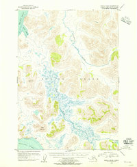
1954 Map of Karluk B-2
USGS Topo · Published 1955About this map
Kodiak Island reveals a complex network of waterways and coastal features in this mid-1950s survey, dominated by the expansive drainage of the Ayakulik River. This river system creates a vast, braided wetland pattern across the central landscape, a sharp contrast to the high ground of VABM Ridge 1508 and Anvil Mountain. The entire land area is managed as part of the Kodiak National Wildlife Refuge, indicating the preserved, natural state of the territory at the time of the survey.
Find a feature on this map
11 named features on this map. Tap any name to fly to it.
Don’t see what you’re looking for? This feature index may not catch every label — zoom into the map to look around manually.
Map Details
Editions of this 1954 Karluk B-2 Map
This is the sole edition of this map. No revisions or reprints were ever made.
Other maps of this area

1951 · Karluk
USGS Topo · 1:250,000

1952 · Karluk
USGS Topo · 1:250,000

1952 · Karluk C-2
USGS Topo · 1:63,360

1952 · Karluk B-2
USGS Topo · 1:63,360

1952 · Karluk B-1
USGS Topo · 1:63,360

1952 · Karluk C-1
USGS Topo · 1:63,360

1952 · Karluk A-1
USGS Topo · 1:63,360
1952 · Karluk B-3
USGS Topo · 1:63,360

1952 · Karluk A-2
USGS Topo · 1:63,360
1954 · Karluk A-1
USGS Topo · 1:63,360