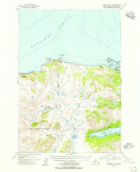
1954 Map of Karluk C-1
USGS Topo · Published 1955About this map
The Karluk River winds through the southwestern reaches of Kodiak Island in this mid-1950s survey, marking a transition from the mountainous interior to the waters of the Shelikof Strait. Large portions of the landscape are protected under the Kodiak National Wildlife Refuge, where the terrain is punctuated by significant survey markers like VABM Cape Uyak 1239 and VABM Rocky Pt 1114. Evidence of seasonal or specialized activity appears along the coastline and inland waterways, with scattered cabin sites and a cluster of abandoned cabins near Larsen Bay.
Find a feature on this map
21 named features on this map. Tap any name to fly to it.
Don’t see what you’re looking for? This feature index may not catch every label — zoom into the map to look around manually.
Map Details
Editions of this 1954 Karluk C-1 Map
This is the sole edition of this map. No revisions or reprints were ever made.
Other maps of this area

1951 · Karluk
USGS Topo · 1:250,000

1951 · Kodiak D-6
USGS Topo · 1:63,360

1952 · Kodiak
USGS Topo · 1:250,000

1952 · Karluk
USGS Topo · 1:250,000

1952 · Karluk C-2
USGS Topo · 1:63,360

1952 · Karluk B-2
USGS Topo · 1:63,360

1952 · Kodiak B-6
USGS Topo · 1:63,360

1952 · Karluk B-1
USGS Topo · 1:63,360

1952 · Karluk C-1
USGS Topo · 1:63,360

1952 · Kodiak C-6
USGS Topo · 1:63,360