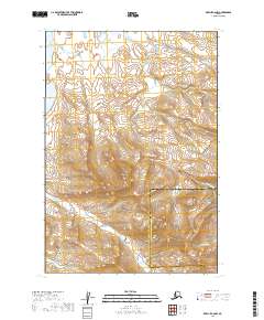
2019 Map of Karluk C-6 NW
USGS Topo · Published 2019About this map
Becharof Lake defines the northern reaches of this coastal wilderness, where its waters meet the tidal inlet of Bellim Bay. The terrain rises sharply toward the southeast into the rugged peaks of the Aleutian Range, creating a dramatic transition from lake-level wetlands to high mountain slopes. This landscape is characterized by a dense network of watercourses, including Becharof Cr and Sulphur Cr, which drain the uplands and reveal the complex drainage patterns typical of the Alaska Peninsula. The convergence of multiple forks, such as N Fork Rex Cr and S Fork Rex Cr, highlights the erosional forces shaping the local geography. The boundary between the Lake and Peninsula and Kodiak Island Boroughs passes through the high ridges, marking an administrative divide across a largely untouched natural expanse.
Find a feature on this map
17 named features on this map. Tap any name to fly to it.
Don’t see what you’re looking for? This feature index may not catch every label — zoom into the map to look around manually.
Map Details
Editions of this 2019 Karluk C-6 NW Map
This is the sole edition of this map. No revisions or reprints were ever made.
Other maps of this area

1943 · Ugashik
USGS Topo · 1:250,000

1948 · Ugashik
USGS Topo · 1:250,000

1949 · Ugashik
USGS Topo · 1:250,000

1951 · Karluk
USGS Topo · 1:250,000

1951 · Ugashik D-1
USGS Topo · 1:63,360

1951 · Ugashik C-1
USGS Topo · 1:63,360

1951 · Karluk D-6
USGS Topo · 1:63,360
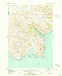
1951 · Karluk C-6
USGS Topo · 1:63,360

1952 · Karluk
USGS Topo · 1:250,000

1963 · Ugashik
USGS Topo · 1:250,000