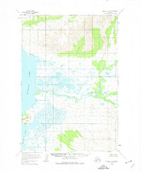
1951 Map of Karluk D-6
USGS Topo · Published 1974About this map
Becharof Lake dominates the western edge of this 1951 survey, its expansive shoreline giving way to the complex hydrology of the Alaska Peninsula. The Kejulik River meanders across the central lowlands, fed by numerous tributaries including Marie Creek and Katrine Creek. The landscape is a mosaic of wetlands and tidal flats, with subtle elevations marked by survey points such as Vabm Maria and Vabm Severson.
Find a feature on this map
10 named features on this map. Tap any name to fly to it.
Don’t see what you’re looking for? This feature index may not catch every label — zoom into the map to look around manually.
Map Details
Editions of this 1951 Karluk D-6 Map
4 editions found
Other maps of this area

1943 · Ugashik
USGS Topo · 1:250,000

1948 · Mt Katmai
USGS Topo · 1:250,000

1948 · Ugashik
USGS Topo · 1:250,000

1949 · Ugashik
USGS Topo · 1:250,000

1951 · Mt Katmai
USGS Topo · 1:250,000

1951 · Karluk
USGS Topo · 1:250,000

1951 · Mount Katmai A-6
USGS Topo · 1:63,360

1951 · Ugashik D-1
USGS Topo · 1:63,360

1951 · Ugashik C-1
USGS Topo · 1:63,360

1951 · Karluk D-6
USGS Topo · 1:63,360