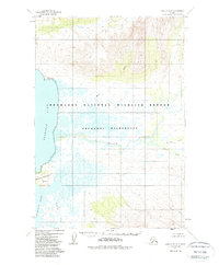
1951 Map of Karluk D-6
USGS Topo · Published 1988About this map
The Becharof Lake shoreline dominates this 1950s study, showcasing the hydrological network of the Becharof National Wildlife Refuge. The map reveals a landscape defined by the winding Kejulik River and its numerous tributaries, including Margaret Creek and Katrine Creek. Human presence is sparse, marked primarily by isolated structures like the Marie Cabin near the mouth of Marie Creek and another Cabin situated along the lower Kejulik. These small outposts suggest the seasonal and remote nature of activity in the area before the formal establishment of the Becharof Wilderness. Along the western edge, the Severson Peninsula juts into the lake, featuring the geodetic marker VABM Severson 490. This survey provides a baseline for the region’s topography before the legislative changes of the 1980s redefined these lands as federally protected wilderness.
Find a feature on this map
14 named features on this map. Tap any name to fly to it.
Don’t see what you’re looking for? This feature index may not catch every label — zoom into the map to look around manually.
Map Details
Editions of this 1951 Karluk D-6 Map
4 editions found
Other maps of this area

1943 · Ugashik
USGS Topo · 1:250,000

1948 · Mt Katmai
USGS Topo · 1:250,000

1948 · Ugashik
USGS Topo · 1:250,000

1949 · Ugashik
USGS Topo · 1:250,000

1951 · Mt Katmai
USGS Topo · 1:250,000

1951 · Karluk
USGS Topo · 1:250,000

1951 · Mount Katmai A-6
USGS Topo · 1:63,360

1951 · Ugashik D-1
USGS Topo · 1:63,360

1951 · Ugashik C-1
USGS Topo · 1:63,360

1951 · Karluk D-6
USGS Topo · 1:63,360