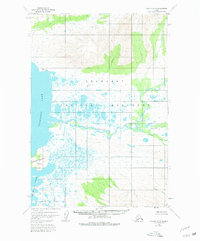
1951 Map of Karluk D-6
USGS Topo · Published 1980About this map
Becharof Lake dominates this 1951 aerial survey of the Alaska Peninsula, showcasing a landscape of complex waterways and unnamed lowlands. This territory, largely defined by the Becharof National Monument, reveals the intricate meandering of the Kejulik River as it winds through wetlands toward the lake. Human presence is minimal, marked only by isolated structures like the Marie Cabin and another unnamed cabin near the riverbanks. The survey captures the unsurveyed and unmarked land lines predetermined by the Bureau of Land Management, emphasizing the area's wilderness character.
Find a feature on this map
13 named features on this map. Tap any name to fly to it.
Don’t see what you’re looking for? This feature index may not catch every label — zoom into the map to look around manually.
Map Details
Editions of this 1951 Karluk D-6 Map
4 editions found
Other maps of this area

1943 · Ugashik
USGS Topo · 1:250,000

1948 · Mt Katmai
USGS Topo · 1:250,000

1948 · Ugashik
USGS Topo · 1:250,000

1949 · Ugashik
USGS Topo · 1:250,000

1951 · Mt Katmai
USGS Topo · 1:250,000

1951 · Karluk
USGS Topo · 1:250,000

1951 · Mount Katmai A-6
USGS Topo · 1:63,360

1951 · Ugashik D-1
USGS Topo · 1:63,360

1951 · Ugashik C-1
USGS Topo · 1:63,360

1951 · Karluk D-6
USGS Topo · 1:63,360