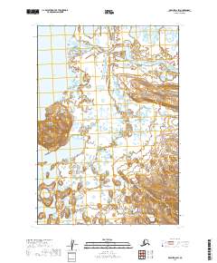
2019 Map of Karluk D-6 SW
USGS Topo · Published 2019About this map
Becharof Lake dominates the western edge of this subarctic landscape on the Alaska Peninsula, where the waters of Becharof Cr feed into the lake's expansive southeastern reaches. The terrain is defined by the prominent Severson Peninsula, which extends into the lake and provides a natural break in the shoreline. To the north, the Kejulik River meanders through a complex network of wetlands and small ponds, illustrating the typical drainage patterns of the Lake and Peninsula Borough. This 2019 survey documents a largely roadless area, showing the land as it exists in a modern state of ecological preservation. The topography transitions from the low-lying lacustrine basins near the shore to more elevated ground in the southeastern sections of the quadrangle.
Find a feature on this map
8 named features on this map. Tap any name to fly to it.
Don’t see what you’re looking for? This feature index may not catch every label — zoom into the map to look around manually.
Map Details
Editions of this 2019 Karluk D-6 SW Map
This is the sole edition of this map. No revisions or reprints were ever made.
Other maps of this area

1943 · Ugashik
USGS Topo · 1:250,000

1948 · Ugashik
USGS Topo · 1:250,000

1949 · Ugashik
USGS Topo · 1:250,000

1951 · Karluk
USGS Topo · 1:250,000

1951 · Ugashik D-1
USGS Topo · 1:63,360

1951 · Ugashik C-1
USGS Topo · 1:63,360

1951 · Karluk D-6
USGS Topo · 1:63,360
1951 · Karluk C-6
USGS Topo · 1:63,360

1952 · Karluk
USGS Topo · 1:250,000

1963 · Ugashik
USGS Topo · 1:250,000