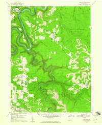
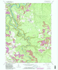
1959 Map of Karthaus
USGS Topo · Published 1961About this map
West Branch Susquehanna River carves a deep, winding course through the center of this landscape, marking the boundary between Clearfield and Centre counties. In the late 1950s, the region was defined by a mix of upland farming settlements and intensive extraction, with numerous strip mines dotting the plateau south of the river. Small enclaves like German Settlement and Cooper Settlement reflect the mid-century agricultural footprint, while St Severins Cem serves as a localized landmark for genealogists tracing early families in Cooper township. Industrial activity is anchored by the New York Central railroad, which follows the river's northern bank near Karthaus, while to the east, the sprawling State Game Lands No 100 occupies the high ground between Sterling Run and Pine Run. The map effectively documents the transition from a river-and-rail economy to one increasingly dominated by surface mining near Drifting and Grassflat.
Find a feature on this map
37 named features on this map. Tap any name to fly to it.
Don’t see what you’re looking for? This feature index may not catch every label — zoom into the map to look around manually.
Map Details
Editions of this 1959 Karthaus Map
5 editions found
Other maps of this area

1908 · Bellefonte
USGS Topo · 1:62,500

1909 · Bellefonte
USGS Topo · 1:62,500

1922 · Philipsburg
USGS Topo · 1:62,500

1928 · Snow Shoe
USGS Topo · 1:48,000

1929 · Karthaus
USGS Topo · 1:62,500

1931 · Show Shoe
USGS Topo · 1:62,500

1932 · Karthaus
USGS Topo · 1:62,500

1939 · Philipsburg
USGS Topo · 1:62,500

1943 · Lewistown
USGS Topo · 1:125,000

1945 · Philipsburg
USGS Topo · 1:62,500