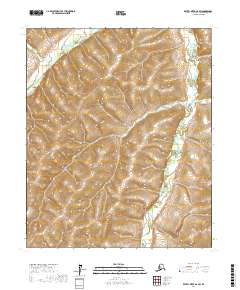
2017 Map of Kateel River A-6 SW
USGS Topo · Published 2017About this map
The Kateel River winds through the northern portion of this interior Alaskan landscape, establishing a drainage pattern that defines the local topography. This 2017 survey by the U.S. Geological Survey illustrates a land shaped by the intricate flow of Arvesta Creek, which meanders through the eastern sections. The terrain is marked by the systematic grid of the Public Land Survey System, spanning several townships including t4s r1w and t5s r1w. While the map reflects a region without established road infrastructure or named settlements, it provides high-resolution data on the elevation changes and hydraulic features essential for understanding the remote environment of the Yukon-Koyukuk Census Area.
Find a feature on this map
11 named features on this map. Tap any name to fly to it.
Don’t see what you’re looking for? This feature index may not catch every label — zoom into the map to look around manually.
Map Details
Editions of this 2017 Kateel River A-6 SW Map
This is the sole edition of this map. No revisions or reprints were ever made.
Other maps of this area

1945 · Nulato
USGS Topo · 1:250,000

1948 · Norton Bay
USGS Topo · 1:250,000

1951 · Candle
USGS Topo · 1:250,000

1951 · Nulato
USGS Topo · 1:250,000

1951 · Norton Bay
USGS Topo · 1:250,000

1951 · Kateel River
USGS Topo · 1:250,000

1952 · Nulato
USGS Topo · 1:250,000

1954 · Candle A-1
USGS Topo · 1:63,360
1955 · Nulato D-6
USGS Topo · 1:63,360
1955 · Norton Bay D-1
USGS Topo · 1:63,360