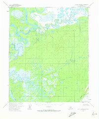
1952 Map of Kateel River B-1
USGS Topo · Published 1973About this map
The Koyukuk River dominates this interior Alaskan landscape, shown here as a complex system of oxbows and active channels. Photogrammetric data from the early 1950s reveals a wilderness defined by water and low-relief terrain, where the river meets the Dulbi River and the meandering Slough. A few isolated structures, labeled simply as Cabin and Cabins, indicate the presence of remote trapping or subsistence sites near Dubin Point and the Base Line. This area is characterized by vast wetlands, including the drainages of Holtnakatna Creek and Cottonwood Creek. The intricate patterns of the river bends and associated swampy areas reflect a landscape largely untouched by infrastructure, providing a baseline for environmental studies of the Koyukuk basin prior to more recent ecological shifts.
Find a feature on this map
9 named features on this map. Tap any name to fly to it.
Don’t see what you’re looking for? This feature index may not catch every label — zoom into the map to look around manually.
Map Details
Editions of this 1952 Kateel River B-1 Map
2 editions found
Other maps of this area

1951 · Kateel River
USGS Topo · 1:250,000

1951 · Melozitna
USGS Topo · 1:250,000

1952 · Kateel River A-2
USGS Topo · 1:63,360

1952 · Kateel River A-1
USGS Topo · 1:63,360

1952 · Kateel River B-1
USGS Topo · 1:63,360

1952 · Kateel River B-2
USGS Topo · 1:63,360
1952 · Melozitna A-6
USGS Topo · 1:63,360

1954 · Kateel River C-2
USGS Topo · 1:63,360

1954 · Melozitna C-6
USGS Topo · 1:63,360

1954 · Kateel River C-1
USGS Topo · 1:63,360