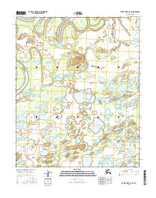
2016 Map of Kateel River D-1 SE
USGS Topo · Published 2016About this map
Cutoff Slough winds through the northern reaches of this landscape, carving a complex network of waterways typical of the Yukon-Koyukuk region. This 2016 survey highlights a dynamic riparian environment where shifting channels like Nuyayatha Slough and Huntington Slough define the terrain. The presence of numerous isolated water bodies, including Whitefish Lake, First Lake, and Boat Lake, suggests a low-lying basin characterized by seasonal flooding and wetland stability. This detailed documentation by the U.S. Geological Survey provides an essential record of the hydrological patterns and land divisions within the Kateel River D-1 SE quadrangle during the early 21st century.
Find a feature on this map
14 named features on this map. Tap any name to fly to it.
Don’t see what you’re looking for? This feature index may not catch every label — zoom into the map to look around manually.
Map Details
Editions of this 2016 Kateel River D-1 SE Map
This is the sole edition of this map. No revisions or reprints were ever made.
Other maps of this area

1951 · Kateel River
USGS Topo · 1:250,000

1951 · Melozitna
USGS Topo · 1:250,000

1954 · Melozitna C-6
USGS Topo · 1:63,360

1954 · Kateel River C-1
USGS Topo · 1:63,360

1954 · Kateel River D-1
USGS Topo · 1:63,360

1954 · Melozitna D-6
USGS Topo · 1:63,360

1955 · Kateel River
USGS Topo · 1:250,000

1956 · Melozitna
USGS Topo · 1:250,000
2016 · Kateel River C-1 NE
USGS Topo · 1:25,000
2016 · Kateel River D-1 SW
USGS Topo · 1:25,000