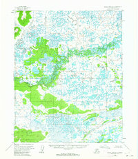
1954 Map of Kateel River D-3
USGS Topo · Published 1964About this map
The South Fork Huslia River meanders through this interior Alaska landscape, forming a complex network of oxbows and wetlands across the central terrain. Photographed in the early 1950s, the map reveals an environment dominated by water and shifting riverbeds, where the drainage of the Nulitna River and the scattered Birch Lakes define the local topography. This region is characterized by thousands of small unnamed ponds and marshes, typical of the subarctic thaw-lake plains found in the Yukon-Koyukuk area. The absence of roads or established trails on this sheet reflects the historical reliance on these river corridors for seasonal movement and subsistence in the Alaskan wilderness before more modern infrastructure arrived in the territory.
Find a feature on this map
3 named features on this map. Tap any name to fly to it.
Don’t see what you’re looking for? This feature index may not catch every label — zoom into the map to look around manually.
Map Details
Editions of this 1954 Kateel River D-3 Map
2 editions found
Other maps of this area

1951 · Shungnak
USGS Topo · 1:250,000

1951 · Kateel River
USGS Topo · 1:250,000

1954 · Kateel River C-4
USGS Topo · 1:63,360

1954 · Kateel River C-2
USGS Topo · 1:63,360

1954 · Kateel River C-3
USGS Topo · 1:63,360

1954 · Kateel River D-3
USGS Topo · 1:63,360

1954 · Kateel River D-4
USGS Topo · 1:63,360

1955 · Shungnak
USGS Topo · 1:250,000

1955 · Kateel River D-2
USGS Topo · 1:63,360

1955 · Kateel River
USGS Topo · 1:250,000