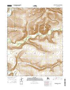
2015 Map of Kateel River D-6 NW
USGS Topo · Published 2015About this map
The Tagagawik River meanders across this landscape, defining the hydrology of a region where the Northwest Arctic Borough Yukon-Koyukuk Census Area boundary creates a formal division across the wilderness. The terrain is characterized by a series of high ridges and deep drainage basins, where the contour lines reveal the complex vertical relief typical of this interior Alaskan corridor. Without named settlements or roads, the map focuses on the raw topography and the water system that dominates the lowlands, providing a clear view of the natural landforms before they are influenced by modern infrastructure. The surveyor's focus remains on the precise township and range divisions, such as t7n r1w and t6n r1w, which provide the only human-imposed grid over the native river systems.
Find a feature on this map
8 named features on this map. Tap any name to fly to it.
Don’t see what you’re looking for? This feature index may not catch every label — zoom into the map to look around manually.
Map Details
Editions of this 2015 Kateel River D-6 NW Map
This is the sole edition of this map. No revisions or reprints were ever made.
Other maps of this area

1951 · Candle
USGS Topo · 1:250,000

1951 · Selawik
USGS Topo · 1:250,000

1951 · Shungnak
USGS Topo · 1:250,000

1951 · Kateel River
USGS Topo · 1:250,000
1954 · Candle D-1
USGS Topo · 1:63,360

1954 · Kateel River D-6
USGS Topo · 1:63,360

1955 · Shungnak
USGS Topo · 1:250,000

1955 · Kateel River
USGS Topo · 1:250,000

1955 · Candle
USGS Topo · 1:250,000

1957 · Selawik
USGS Topo · 1:250,000