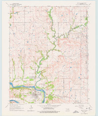
1964 Map of Kaw City
USGS Topo · Published 1977About this map
The Arkansas River winds through the heart of this mid-1960s landscape, marking the boundary between the Longwood township and the Osage Indian Reservation. Before the river was significantly altered by modern dam projects, Kaw City stood as a primary hub for the region, serviced by the Atchison Topeka and Santa Fe railroad line. The settlement of Washunga lies just to the north, accompanied by the Washunga Cem, while the rugged riverbanks are defined by features like Oxbow Bend.
Find a feature on this map
23 named features on this map. Tap any name to fly to it.
Don’t see what you’re looking for? This feature index may not catch every label — zoom into the map to look around manually.
Map Details
Editions of this 1964 Kaw City Map
4 editions found

Other maps of this area

1916 · Foraker
USGS Topo · 1:62,500

1932 · Fairfax
USGS Topo · 1:62,500

1935 · Kaw
USGS Topo · 1:62,500

1936 · Belford
USGS Topo · 1:62,500

1955 · Enid
USGS Topo · 1:250,000

1958 · Enid
USGS Topo · 1:250,000

1963 · Charley Creek
USGS Topo · 1:24,000

1963 · Uncas
USGS Topo · 1:24,000

1963 · Kaw City NW
USGS Topo · 1:24,000

1964 · Charley Creek NE
USGS Topo · 1:24,000