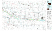
1985 Map of Kearney
USGS Topo · Published 1985About this map
The Platte River corridor defines the mid-1980s landscape of south-central Nebraska, serving as a vital artery for both natural resources and transcontinental transportation. The Union Pacific railroad and Interstate 80 parallel the river’s north bank, linking established agricultural centers like Lexington and Cozad to the regional hub of Kearney. This era shows a heavily managed hydraulic system, where the Gothenburg Canal and Phelps County Canal divert water to support the surrounding plains.
Find a feature on this map
62 named features on this map. Tap any name to fly to it.
Don’t see what you’re looking for? This feature index may not catch every label — zoom into the map to look around manually.
Map Details
Editions of this 1985 Kearney Map
2 editions found
Other maps of this area

1894 · Kearney
USGS Topo · 1:62,500

1894 · Minden
USGS Topo · 1:62,500

1896 · Lexington
USGS Topo · 1:125,000

1896 · Holdrege
USGS Topo · 1:125,000

1896 · Kearney
USGS Topo · 1:125,000

1896 · Arapahoe
USGS Topo · 1:125,000

1896 · Wood River
USGS Topo · 1:125,000

1897 · Red Cloud
USGS Topo · 1:125,000

1898 · Arapahoe
USGS Topo · 1:125,000

1899 · Lexington
USGS Topo · 1:125,000