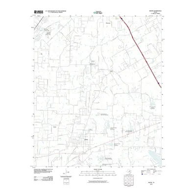
2010 Map of Keene
USGS Topo · Published 2010About this map
Keene serves as the primary hub of this North Texas landscape, where the grid of a growing town meets a network of creeks and small-scale water management projects. The map documents a transition from rural homesteads to modern residential developments, particularly around Marystown and Briaroaks in the north. This era is defined by the extensive work of the Soil Conservation Service, which established numerous flood-control structures like Soil Conservation Service Site 33 Dam and Soil Conservation Service Site 35 Dam across the local drainages of Turkey Creek and North Fork Chambers Creek. Genealogists and local historians will find value in the clear positioning of Marystown Cemetery, Hopewell Cemetery, and Keene Cemetery, which anchor the early settlement patterns of the region. The map also captures the local aviation footprint at Stol Field and the recreational waters of Lake Alvarado in the southeastern corner.
Find a feature on this map
94 named features on this map. Tap any name to fly to it.
Don’t see what you’re looking for? This feature index may not catch every label — zoom into the map to look around manually.
Map Details
Editions of this 2010 Keene Map
This is the sole edition of this map. No revisions or reprints were ever made.
Other maps of this area

1891 · Cleburne
USGS Topo · 1:125,000

1894 · Cleburne
USGS Topo · 1:125,000

1894 · Fort Worth
USGS Topo · 1:125,000

1954 · Dallas
USGS Topo · 1:250,000

1955 · Burleson
USGS Topo · 1:24,000

1955 · Primrose
USGS Topo · 1:24,000

1958 · Dallas
USGS Topo · 1:250,000

1959 · Mansfield
USGS Topo · 1:24,000
1959 · Arlington
USGS Topo · 1:62,500

1960 · Keene
USGS Topo · 1:24,000