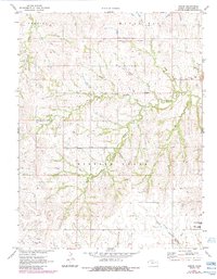
1971 Map of Keene
USGS Topo · Published 1984About this map
The Old Indian Treaty Boundary cuts horizontally across the northern landscape of Wabaunsee County, marking a significant historical line in the Kansas terrain. This survey reflects the rural character of Mission Creek and Newbury townships during the early 1970s, before 1980s updates noted infrastructure like the sewage disposal ponds and the Wabaunsee East High Sch near the southern edge. The settlement of Keene serves as a local focal point, surrounded by small community landmarks such as the Wesleyan Ch and Keene Cem. Waterways dominate the topography, with Snokomo Creek and Beach Creek feeding into the larger drainage systems of the South Branch Wakarusa River. For researchers, the map provides a clear look at the spatial relationship between family burial grounds like Mission View Cem and the creek-fed valleys that defined early land tracts.
Find a feature on this map
19 named features on this map. Tap any name to fly to it.
Don’t see what you’re looking for? This feature index may not catch every label — zoom into the map to look around manually.
Map Details
Editions of this 1971 Keene Map
2 editions found
Other maps of this area

1885 · Eskridge
USGS Topo · 1:125,000

1889 · Burlingame
USGS Topo · 1:125,000

1889 · Wamego
USGS Topo · 1:125,000

1889 · Eskridge
USGS Topo · 1:125,000

1889 · Topeka
USGS Topo · 1:125,000

1894 · Eskridge
USGS Topo · 1:125,000

1894 · Burlingame
USGS Topo · 1:125,000

1894 · Topeka
USGS Topo · 1:125,000

1894 · Wamego
USGS Topo · 1:125,000

1947 · Lawrence
USGS Topo · 1:250,000