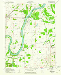
1959 Map of Keensburg
USGS Topo · Published 1961About this map
The Wabash River serves as the winding boundary between Illinois and Indiana in this late-1950s survey, dictating the development of the river bottomlands. On the Illinois side, Keensburg and Rochester sit alongside the New York Central Railroad, which parallels the water's edge. This region is heavily defined by its drainage and petroleum history, evidenced by an extensive network of ditches like Sumner Ditch and Stormont Ditch, alongside numerous oil wells dotting the landscape. Cultural landmarks include the Purdue University Horticultural Farm and several family-named burial sites such as the Le Gier-Lovellette Cemetery. The map also captures several smaller riverbank settlements like Crawleyville and Jimtown, which are positioned near the prominent McCleary Bluffs and the meander of Big Bayou.
Find a feature on this map
46 named features on this map. Tap any name to fly to it.
Don’t see what you’re looking for? This feature index may not catch every label — zoom into the map to look around manually.
Map Details
Editions of this 1959 Keensburg Map
Other maps of this area

1901 · Princeton
USGS Topo · 1:62,500

1901 · Haubstadt
USGS Topo · 1:62,500

1903 · Haubstadt
USGS Topo · 1:62,500

1903 · New Harmony
USGS Topo · 1:62,500

1903 · Princeton
USGS Topo · 1:62,500

1903 · Patoka
USGS Topo · 1:125,000

1904 · Mount Carmel
USGS Topo · 1:62,500

1938 · New Harmony
USGS Topo · 1:62,500

1956 · Vincennes
USGS Topo · 1:250,000

1957 · Vincennes
USGS Topo · 1:250,000