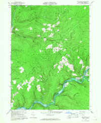
1966 Map of Kelletteville
USGS Topo · Published 1967About this map
Kellettville and the winding course of Tionesta Creek dominate this mid-century portrait of Forest County's heartland. Much of the terrain lies within the Allegheny National Forest, where the landscape is marked by the legacy of resource extraction, evidenced by numerous Gas Wells and Oil Wells scattered across the ridges. The 1960s survey captures the area as the Tionesta Reservoir backs up behind its dam, creating Newtown Flats and inundating the valley floor. Small upland settlements like Starr, Crystal Springs, and Queen appear alongside essential community landmarks such as Whig Hill Cemetery and Mt Zion Church. The transition from the old timber and rail era is visible in several stretches of Old Railroad Grade that follow the creek beds, now bypassed by more modern tracks and a prominent Pipeline cutting across the northern reaches of Hickory Valley.
Find a feature on this map
56 named features on this map. Tap any name to fly to it.
Don’t see what you’re looking for? This feature index may not catch every label — zoom into the map to look around manually.
Map Details
Editions of this 1966 Kelletteville Map
3 editions found
Other maps of this area

1918 · Loleta
USGS Topo · 1:62,500

1922 · Tionesta
USGS Topo · 1:62,500

1924 · Tionesta
USGS Topo · 1:62,500

1927 · Tidioute
USGS Topo · 1:48,000

1930 · Tidioute
USGS Topo · 1:62,500

1935 · Sheffield
USGS Topo · 1:48,000

1936 · Marienville
USGS Topo · 1:48,000

1941 · Sheffield
USGS Topo · 1:62,500

1941 · Marienville
USGS Topo · 1:62,500

1946 · Tionesta
USGS Topo · 1:62,500
Featured Places
- Hickory Township, PA
- Kingsley Township, PA
- Crystal Springs, Kingsley Township
- Green Township, PA
- Yellow Hammer, Hickory Township