
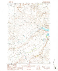
1963 Map of Kelley
USGS Topo · Published 1966About this map
Kelley (Site) sits at the heart of this mid-century survey of the high plains, positioned along the border of the Petroleum and Musselshell county line. The landscape is defined by the drainage patterns of Mud Creek and the intermittent flows of Salt Sage Coulee and Johnson Coulee. This era of mapping documents a transition from early settlement to industrial extraction, evidenced by the presence of Oil Wells and an Oil Well scattered across the northern sections near Rattlesnake Butte. The scarcity of permanent structures and the reliance on features like the Spring for water highlight the arid, demanding nature of this Central Montana ranching and oil country during the early 1960s.
Find a feature on this map
9 named features on this map. Tap any name to fly to it.
Don’t see what you’re looking for? This feature index may not catch every label — zoom into the map to look around manually.
Map Details
Editions of this 1963 Kelley Map
This is the sole edition of this map. No revisions or reprints were ever made.
Other maps of this area

1954 · Roundup
USGS Topo · 1:250,000

1958 · Roundup
USGS Topo · 1:250,000

1963 · Petrolia Lake
USGS Topo · 1:24,000
1963 · Akers Ranch
USGS Topo · 1:24,000

1963 · Musselshell NW
USGS Topo · 1:24,000
1963 · Breed Spring
USGS Topo · 1:24,000
1963 · Mud Spring
USGS Topo · 1:24,000

1986 · Crowley Dam
USGS Topo · 1:24,000
1986 · Jim Coulee
USGS Topo · 1:24,000
1986 · Winnett South
USGS Topo · 1:24,000