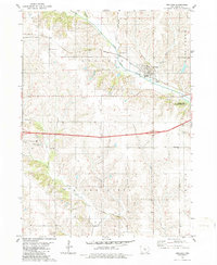
1980 Map of Kellogg
USGS Topo · Published 1986About this map
The town of Kellogg serves as the central hub of this Iowa landscape, situated where the Chicago Rock Island and Pacific railroad tracks cross the North Skunk River. This 1980s-era documentation reveals a rural environment transitioning between traditional agriculture and modern infrastructure, evidenced by the prominent 4 Lane highway cutting through the center and the presence of specialized facilities like the County Home and Beacon Light Sch.
Find a feature on this map
31 named features on this map. Tap any name to fly to it.
Don’t see what you’re looking for? This feature index may not catch every label — zoom into the map to look around manually.
Map Details
Editions of this 1980 Kellogg Map
2 editions found
Other maps of this area

1954 · Des Moines
USGS Topo · 1:250,000

1956 · Des Moines
USGS Topo · 1:250,000

1957 · Des Moines
USGS Topo · 1:250,000

1965 · Newton
USGS Topo · 1:24,000

1965 · Monroe
USGS Topo · 1:24,000

1969 · Des Moines
USGS Topo · 1:250,000

1975 · Baxter SE
USGS Topo · 1:24,000

1980 · Newburg
USGS Topo · 1:24,000

1980 · Sully
USGS Topo · 1:24,000
1980 · Alloway Creek
USGS Topo · 1:24,000