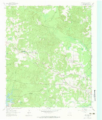
1962 Map of Kellyville
USGS Topo · Published 1974About this map
Kellyville and the neighboring community of Berea center this 1962 landscape in Marion County, where the Louisiana and Arkansas and Kansas City Southern railroads converge. The terrain is defined by the expansive waters of Lake O' The Pines and the winding course of Black Cypress Bayou to the north. Local civic life is anchored by institutions like the Jefferson Rural Academy and Morning Star Church, while the presence of a Drill Hole and Oil Well indicates the active extraction industry of the era. The mapping of the East Abutment Recreational Area and several spillways highlights the post-war development of water management and public leisure infrastructure. Genealogists will find value in the precise locations of family-named landmarks such as Beamer-Davis Cem and the small settlement of Sarber along the western rail line.
Find a feature on this map
29 named features on this map. Tap any name to fly to it.
Don’t see what you’re looking for? This feature index may not catch every label — zoom into the map to look around manually.
Map Details
Editions of this 1962 Kellyville Map
Other maps of this area

1956 · Tyler
USGS Topo · 1:250,000

1961 · Cunningham Creek
USGS Topo · 1:24,000

1961 · Lassater
USGS Topo · 1:24,000

1961 · Harleton
USGS Topo · 1:24,000

1962 · Kellyville
USGS Topo · 1:24,000

1962 · Lanier
USGS Topo · 1:24,000

1962 · Marshall NW
USGS Topo · 1:24,000

1962 · Woodlawn
USGS Topo · 1:24,000

1962 · Jefferson
USGS Topo · 1:24,000

1962 · Avinger
USGS Topo · 1:24,000