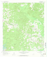
1962 Map of Kellyville
USGS Topo · Published 1983About this map
Kellyville stands as a central point of activity along the Louisiana And Arkansas railroad in this eastern Texas landscape. The map reveals a region transitioning from traditional rural settlements to modern utility and recreation, marked by the presence of numerous Pipeline corridors and the expansive waters of Lake O' The Pines. Educational and spiritual life is anchored by the Jefferson Rural Academy and local congregations such as Morning Star Church.
Find a feature on this map
32 named features on this map. Tap any name to fly to it.
Don’t see what you’re looking for? This feature index may not catch every label — zoom into the map to look around manually.
Map Details
Editions of this 1962 Kellyville Map
Other maps of this area

1956 · Tyler
USGS Topo · 1:250,000

1961 · Cunningham Creek
USGS Topo · 1:24,000

1961 · Lassater
USGS Topo · 1:24,000

1961 · Harleton
USGS Topo · 1:24,000

1962 · Kellyville
USGS Topo · 1:24,000

1962 · Lanier
USGS Topo · 1:24,000

1962 · Marshall NW
USGS Topo · 1:24,000

1962 · Woodlawn
USGS Topo · 1:24,000

1962 · Jefferson
USGS Topo · 1:24,000

1962 · Avinger
USGS Topo · 1:24,000