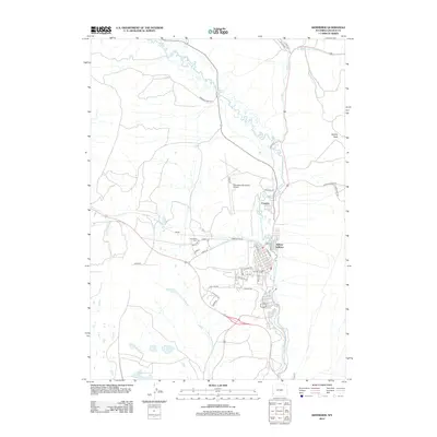
2012 Map of Kemmerer
USGS Topo · Published 2012About this map
Hams Fork meanders through the center of this Lincoln County landscape, defining the layout of the neighboring communities of Frontier and Willow Addition. The 2012 topography shows a dense network of local roads including Lignite Ave and Sage Ave, reflecting the modern residential footprint of the area. To the west, the settlement of Moyer and the Hamstork Cem sit near the Kemmerer Municipal Airport, marking a transition from the urban center to the more open high-desert terrain. Transportation routes like Dempsey Road 4211 and Fossil Butte Rd provide access to the surrounding hills, where features like Quealy Peak and the drainage of Willow Cr dominate the horizon. This period illustrates the established infrastructure supporting the town, from its systematic street grid to its outlying rural connections.
Find a feature on this map
41 named features on this map. Tap any name to fly to it.
Don’t see what you’re looking for? This feature index may not catch every label — zoom into the map to look around manually.
Map Details
Editions of this 2012 Kemmerer Map
This is the sole edition of this map. No revisions or reprints were ever made.
Other maps of this area

1954 · Ogden
USGS Topo · 1:250,000

1954 · Kemmerer
USGS Topo · 1:62,500

1958 · Ogden
USGS Topo · 1:250,000

1960 · Ogden
USGS Topo · 1:250,000

1962 · Elkol
USGS Topo · 1:24,000

1962 · Warfield Creek
USGS Topo · 1:24,000

1969 · Willow Springs
USGS Topo · 1:24,000
1969 · Round Mountain
USGS Topo · 1:24,000
1969 · Little Round Mountain
USGS Topo · 1:24,000
1979 · Kemmerer
USGS Topo · 1:100,000