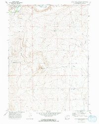
1969 Map of Little Round Mountain
USGS Topo · Published 1973About this map
The Union Pacific railroad cuts through the northwestern corner of this high-altitude landscape, following the course of Hams Fork as it winds past a local Waterfall. This 1969 field-checked survey reveals a rugged interior dominated by the namesake Little Round Mountain and a series of seasonal drainages, including the aptly named Dry Muddy Creek.
Find a feature on this map
14 named features on this map. Tap any name to fly to it.
Don’t see what you’re looking for? This feature index may not catch every label — zoom into the map to look around manually.
Map Details
Editions of this 1969 Little Round Mountain Map
2 editions found
Other maps of this area

1954 · Ogden
USGS Topo · 1:250,000

1954 · Kemmerer
USGS Topo · 1:62,500

1958 · Ogden
USGS Topo · 1:250,000

1960 · Ogden
USGS Topo · 1:250,000

1962 · Cumberland Gap
USGS Topo · 1:24,000

1962 · Elkol
USGS Topo · 1:24,000

1969 · Willow Springs
USGS Topo · 1:24,000

1969 · Roberson Creek
USGS Topo · 1:24,000

1969 · Hampton
USGS Topo · 1:24,000
1969 · Mulkay Spring
USGS Topo · 1:24,000