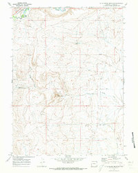
1969 Map of Little Round Mountain
USGS Topo · Published 1973About this map
Hams Fork winds through the northwestern corner of this Lincoln County landscape, shadowed by the Union Pacific railroad and a small Roadside Park. The terrain is defined by dramatic relief, transitioning from the high point of Little Round Mountain in the center of the quadrangle to the valley of Dry Muddy Creek to the south. This late 1960s survey captures a rural environment marked by essential utility infrastructure and isolated water sources. Multiple Springs, including Coyote Spring and Little Round Mountain Spring, serve as vital landmarks across the arid high-country. The presence of a prominent Pipeline and scattered Drill Holes underscores the industrial activity and energy exploration that shaped the land use patterns in this part of Wyoming.
Find a feature on this map
18 named features on this map. Tap any name to fly to it.
Don’t see what you’re looking for? This feature index may not catch every label — zoom into the map to look around manually.
Map Details
Editions of this 1969 Little Round Mountain Map
2 editions found
Other maps of this area

1954 · Ogden
USGS Topo · 1:250,000

1954 · Kemmerer
USGS Topo · 1:62,500

1958 · Ogden
USGS Topo · 1:250,000

1960 · Ogden
USGS Topo · 1:250,000

1962 · Cumberland Gap
USGS Topo · 1:24,000

1962 · Elkol
USGS Topo · 1:24,000

1969 · Willow Springs
USGS Topo · 1:24,000

1969 · Roberson Creek
USGS Topo · 1:24,000

1969 · Hampton
USGS Topo · 1:24,000
1969 · Mulkay Spring
USGS Topo · 1:24,000