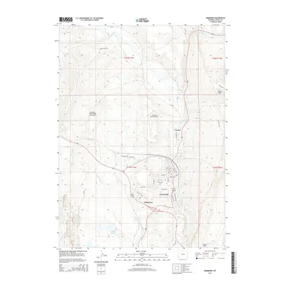
2015 Map of Kemmerer
USGS Topo · Published 2015About this map
Kemmerer and Diamondville anchor this 2015 study, situated along the winding course of the Hams Fork in Lincoln County. The map details a landscape defined by significant infrastructure and topography, including the Kemmerer Municipal Airport and the massive Naughton Ash Pond Number 2 to the south. Residential development is clustered in the river valley, with street names like Onyx St and Emerald St appearing in the Diamondville grid, while the northern settlement of Frontier sits nestled near the hills.
Find a feature on this map
42 named features on this map. Tap any name to fly to it.
Don’t see what you’re looking for? This feature index may not catch every label — zoom into the map to look around manually.
Map Details
Editions of this 2015 Kemmerer Map
This is the sole edition of this map. No revisions or reprints were ever made.
Other maps of this area

1954 · Ogden
USGS Topo · 1:250,000

1954 · Kemmerer
USGS Topo · 1:62,500

1958 · Ogden
USGS Topo · 1:250,000

1960 · Ogden
USGS Topo · 1:250,000

1962 · Elkol
USGS Topo · 1:24,000

1962 · Warfield Creek
USGS Topo · 1:24,000

1969 · Willow Springs
USGS Topo · 1:24,000
1969 · Round Mountain
USGS Topo · 1:24,000
1969 · Little Round Mountain
USGS Topo · 1:24,000
1979 · Kemmerer
USGS Topo · 1:100,000