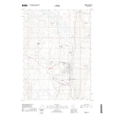
2017 Map of Kemmerer
USGS Topo · Published 2017About this map
Hams Fork winds through this high-altitude corridor of Lincoln County, anchoring a string of settlements that define the region's industrial and civic footprint. The city of Kemmerer sits at the heart of the map, flanked by the adjacent communities of Diamondville and Frontier, and the outlying settlement of Oakley to the south. This area is geographically significant as it straddles the Colorado River Divide Great Basin, a continental hydrologic boundary that dictates the flow of local waters like N Fork Little Muddy Cr and Willow Cr. For genealogists and local historians, the map identifies three distinct burial grounds: Kemmerer City Cem, South Lincoln Cem, and the smaller Hamstork Cem. The landscape is a mix of urban street grids, such as Diamondville Ave, and high-country landmarks like Quealy Peak.
Find a feature on this map
45 named features on this map. Tap any name to fly to it.
Don’t see what you’re looking for? This feature index may not catch every label — zoom into the map to look around manually.
Map Details
Editions of this 2017 Kemmerer Map
This is the sole edition of this map. No revisions or reprints were ever made.
Other maps of this area

1954 · Ogden
USGS Topo · 1:250,000

1954 · Kemmerer
USGS Topo · 1:62,500

1958 · Ogden
USGS Topo · 1:250,000

1960 · Ogden
USGS Topo · 1:250,000

1962 · Elkol
USGS Topo · 1:24,000

1962 · Warfield Creek
USGS Topo · 1:24,000

1969 · Willow Springs
USGS Topo · 1:24,000
1969 · Round Mountain
USGS Topo · 1:24,000
1969 · Little Round Mountain
USGS Topo · 1:24,000
1979 · Kemmerer
USGS Topo · 1:100,000