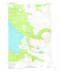
1951 Map of Kenai A-2
USGS Topo · Published 1980About this map
Kenai National Moose Range dominates this mid-century topographic survey of the Kenai Peninsula, showcasing a vast network of glacial runoff and wilderness drainage. The landscape is defined by the massive Tustumena Lake on the western edge and the formidable Tustumena Glacier to the southeast. Between these landmarks, a series of creeks and rivers, including the Funny River and Bear Creek, carve through the terrain. Evidence of seasonal or specialized activity is minimal, marked only by isolated Cabin sites near the shore of the lake and along the Seward Base Line. These scattered structures indicate a landscape utilized for trapping or hunting rather than permanent settlement. Higher elevations feature numerous remote water bodies like Wolverine Lake and Timberline Lake, while the eastern portion of the sheet rises toward Crater Lake and Indian Creek.
Find a feature on this map
21 named features on this map. Tap any name to fly to it.
Don’t see what you’re looking for? This feature index may not catch every label — zoom into the map to look around manually.
Map Details
Editions of this 1951 Kenai A-2 Map
5 editions found
Other maps of this area

1944 · Kenai
USGS Topo · 1:250,000

1950 · Kenai
USGS Topo · 1:250,000

1950 · Kenai B-1
USGS Topo · 1:63,360

1950 · Seldovia D-2
USGS Topo · 1:63,360

1950 · Kenai B-3
USGS Topo · 1:63,360

1951 · Seldovia
USGS Topo · 1:250,000

1951 · Seldovia D-3
USGS Topo · 1:63,360

1951 · Kenai B-2
USGS Topo · 1:63,360

1951 · Kenai A-3
USGS Topo · 1:63,360

1951 · Kenai A-2
USGS Topo · 1:63,360