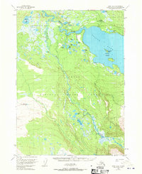
1951 Map of Kenai B-2
USGS Topo · Published 1970About this map
The Kenai National Moose Range dominates this mid-century portrait of the Kenai Peninsula, showcasing a landscape defined by its intricate river systems and glacial lakes. Centered on the confluence where the Killey River meets the Kenai River, the map reveals a wilderness of wetlands and uplands before modern development transformed the region. The presence of the Skilak Guard Station on the shores of Skilak Lake highlights the early federal management of this habitat, which was established to protect the local moose populations. This survey captures the seasonal character of the terrain, specifically noting that the swamps portrayed, such as those near Funny River and Harvey Lake, indicate the wettest areas as interpreted from 1950 aerial photography. Scattered Cabin and Cabins labels suggest a sparse, seasonal human presence focused on the rivers and lakes like Browns Lake and Olson Lake.
Find a feature on this map
27 named features on this map. Tap any name to fly to it.
Don’t see what you’re looking for? This feature index may not catch every label — zoom into the map to look around manually.
Map Details
Editions of this 1951 Kenai B-2 Map
5 editions found
Other maps of this area

1944 · Kenai
USGS Topo · 1:250,000

1950 · Kenai
USGS Topo · 1:250,000

1950 · Kenai C-3
USGS Topo · 1:63,360

1950 · Kenai B-1
USGS Topo · 1:63,360

1950 · Kenai B-3
USGS Topo · 1:63,360

1951 · Kenai B-2
USGS Topo · 1:63,360

1951 · Kenai C-1
USGS Topo · 1:63,360

1951 · Kenai C-2
USGS Topo · 1:63,360

1951 · Kenai A-3
USGS Topo · 1:63,360

1951 · Kenai A-2
USGS Topo · 1:63,360