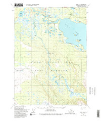
1951 Map of Kenai B-2
USGS Topo · Published 1994About this map
Skilak Lake dominates the upper portion of this survey, serving as a focal point for the region's wilderness management and early backcountry access. The Skilak Guard Station stands near the shoreline, marking a point of official presence in a landscape otherwise defined by glacial waters and expansive wetlands. The presence of the Skilak Lake Road and the Funny River Trail (Pack) indicates the early infrastructure developed to navigate the Kenai Peninsula Borough.
Find a feature on this map
31 named features on this map. Tap any name to fly to it.
Don’t see what you’re looking for? This feature index may not catch every label — zoom into the map to look around manually.
Map Details
Editions of this 1951 Kenai B-2 Map
5 editions found
Other maps of this area

1944 · Kenai
USGS Topo · 1:250,000

1950 · Kenai
USGS Topo · 1:250,000

1950 · Kenai C-3
USGS Topo · 1:63,360

1950 · Kenai B-1
USGS Topo · 1:63,360

1950 · Kenai B-3
USGS Topo · 1:63,360

1951 · Kenai B-2
USGS Topo · 1:63,360

1951 · Kenai C-1
USGS Topo · 1:63,360

1951 · Kenai C-2
USGS Topo · 1:63,360

1951 · Kenai A-3
USGS Topo · 1:63,360

1951 · Kenai A-2
USGS Topo · 1:63,360