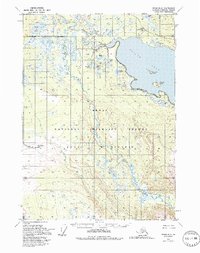
1951 Map of Kenai B-2
USGS Topo · Published 1994About this map
The Kenai River winds through this 1951 landscape, serving as a primary corridor through what is now the Kenai National Wildlife Refuge. This portion of the Kenai Peninsula is characterized by a complex network of glacial lakes and river systems, including the massive Skilak Lake and the meandering Killey River. The area was largely undeveloped during this era, though human presence is marked by isolated structures such as the Skilak Guard Station and scattered cabins. The presence of the Funny River Trail (Pack) indicates the reliance on pack animal transportation for navigating the interior wetlands and forests before more modern infrastructure emerged. Numerous smaller water bodies like Browns Lake, Torpedo Lake, and Harvey Lake are documented across the terrain, illustrating the dense hydrological environment of the Kenai Wilderness.
Find a feature on this map
34 named features on this map. Tap any name to fly to it.
Don’t see what you’re looking for? This feature index may not catch every label — zoom into the map to look around manually.
Map Details
Editions of this 1951 Kenai B-2 Map
5 editions found
Other maps of this area

1944 · Kenai
USGS Topo · 1:250,000

1950 · Kenai
USGS Topo · 1:250,000

1950 · Kenai C-3
USGS Topo · 1:63,360

1950 · Kenai B-1
USGS Topo · 1:63,360

1950 · Kenai B-3
USGS Topo · 1:63,360

1951 · Kenai B-2
USGS Topo · 1:63,360

1951 · Kenai C-1
USGS Topo · 1:63,360

1951 · Kenai C-2
USGS Topo · 1:63,360

1951 · Kenai A-3
USGS Topo · 1:63,360

1951 · Kenai A-2
USGS Topo · 1:63,360