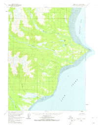
1958 Map of Kenai B-7
USGS Topo · Published 1974About this map
The wild coastline of the Kenai Peninsula meets the waters of Cook Inlet in this mid-century survey. The landscape is defined by the drainage systems of the Crescent River, Polly Creek, and Redoubt Creek, which carve through the terrain toward an extensive Tidal Flat along Redoubt Bay. This area lacks any road network, showing only isolated signs of human activity such as the Cabins located near the mouth of the Crescent River and a single Cabin positioned north of Redoubt Pt. High-altitude surveying is evident through established benchmarks like Vabm Harriet 284 and the Redoubt Astro landmark. Smaller interior water bodies including Bear Lake and Wadell Lake sit in the lowlands between the mountain slopes and the sea, illustrating the complex hydrography of the Alaskan coast before modern development.
Find a feature on this map
17 named features on this map. Tap any name to fly to it.
Don’t see what you’re looking for? This feature index may not catch every label — zoom into the map to look around manually.
Map Details
Editions of this 1958 Kenai B-7 Map
2 editions found
Other maps of this area

1944 · Kenai
USGS Topo · 1:250,000

1950 · Kenai
USGS Topo · 1:250,000
1958 · Kenai A-8
USGS Topo · 1:63,360
1958 · Kenai A-7
USGS Topo · 1:63,360

1958 · Kenai B-7
USGS Topo · 1:63,360

1958 · Kenai C-6
USGS Topo · 1:63,360

1958 · Kenai B-8
USGS Topo · 1:63,360

1958 · Kenai C-8
USGS Topo · 1:63,360

1958 · Kenai C-7
USGS Topo · 1:63,360
1958 · Kenai B-6
USGS Topo · 1:63,360